Contents
What is GPS?
GPS is an acronym for Global Positioning System, a worldwide navigation
and positioning system developed by the US Department of Defense for both
military and civilian use. GPS can determine the location of an object on
earth with an accuracy ranging from tens of meters down to millitmeters,
depending on the receiver and signal processing technology. This
technology permits military, civilian and scientific users to obtain
three-dimensional locations near the Earth's surface with unprecedented
precision. GPS has many applications; a navigational tool in boating and
hiking, while the military applications cover a wide range of operational,
strategic and tactical disciplines.
How does GPS work?
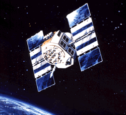
The Global Positioning System consists of a network of 24 broadcasting
satellites orbiting the earth at a height of more than 20,000km. GPS also
consists of receivers on the ground, which listen to and interpret the
transmissions of the satellites. Stations on the earth carefully monitor
the orbit of each satellite, maintaining a highly accurate record of the
satellites instantaneous position. The knowledge of the precise position
of the satellites allows them to be used as reference points, from which
GPS receivers on earth can determine their position. This technique of
determining the position of an object is called ranging.
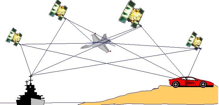
The concept of ranging is best illustrated by example.
Consider one satellite that is a distance of 25,000 kilometers from a
person holding a GPS receiver. Then the person's position is known to
be somewhere on a sphere 25,000 km in radius, centered on the
satellite. However, the exact location of the person on that sphere
is yet unknown. If, at the same time, the distance from the person to
a second satellite can be discovered to be 20,000 km, then a second
sphere of radius 20,000 km on which the person is positioned can be
determined. Thus the person must be on the circle formed by the
intersection of the two spheres of position. A third satellite
provides yet a third sphere, which narrows down the location of the
person to exactly two points. One of these points is often an
impossible solution, frequently several thousand kilometers off in
space, thus three satellite ranges can determine the precise position
of the person. Three satellites provide enough information to find
the x, y, and z coordinates (measured from the center of mass of the
earth). However, in practice, four satellites are required to
pinpoint a position, for reasons that will soon become clear.
In the above model of ranging, the distance between one
satellite and the person on earth is given to be 20,000 km. However,
no mention was made as to how the distance was determined. The Global
Positioning System works by having each of the 21 active satellites
constantly radiate microwaves. These microwaves are received by the
GPS receiver, which can use the method of ranging to locate its
position. The distance from the receiver to one satellite is measured
in the following way. The satellite and receiver are controlled by
separate clocks. The satellites are set as accurately as possible
with an atomic clock, and are assumed to be synchronized with one
another. At some known time a satellite emits a signal in the form of
microwaves. This signal reaches the receiver after a certain interval
has passed. Since microwaves travel at the speed of light, a known
velocity and a known time allows the receiver to determine the
distance to the satellite. Thus it is important that the time be
measured precisely in order to accurately measure distance, as an
error of the synchronization of the two clocks of one microsecond
creates an error of 300 meters. This requires a fourth satellite,
since a fourth variable, time, has been added to the unknowns which
previously included only the x, y, and z distances.
What is the satellite network like?
The 21 functioning satellites are evenly spaced in circular
orbits inclined 55 degrees to the equatorial plane, approximately
20,000 km above the surface of the earth. At a height of over three
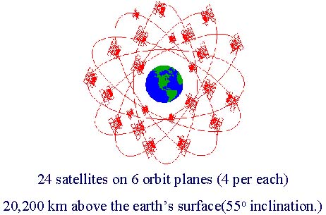 times the radius of the earth, each satellite orbits the earth once
every twelve hours. A particular satellite is visible to a user on
earth for approximately five hours each rotation. Depending on the
location of the user and the time of day, between four and ten
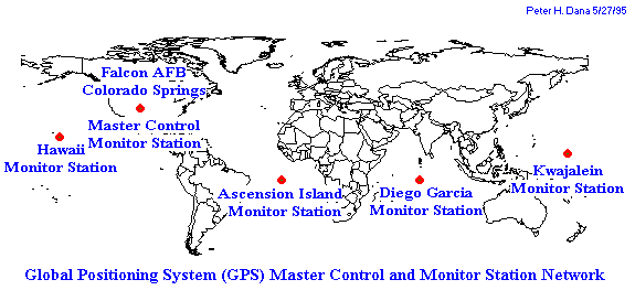
satellites are visible at any time. Five control stations, spaced
evenly around the world, control the satellites. These stations are
responsible for predicting and correcting the orbits of the
satellites, and for transmitting data up to the satellites, including
clock corrections.
times the radius of the earth, each satellite orbits the earth once
every twelve hours. A particular satellite is visible to a user on
earth for approximately five hours each rotation. Depending on the
location of the user and the time of day, between four and ten
satellites are visible at any time. Five control stations, spaced
evenly around the world, control the satellites. These stations are
responsible for predicting and correcting the orbits of the
satellites, and for transmitting data up to the satellites, including
clock corrections.
How does the GPS signal work?
The satellite broadcasts two carrier waves, the L1 carrier wave at
1575.42 MHz, and L2 at 1227.60 MHz. These dual frequencies are chosen to
eliminate ionospheric dispersion, one of the major sources of systematic
range error. The pseudoranges, which are derived from signal travel time
to the receiver, use two pseudorandom noise (PRN) codes. These codes are
modulated onto the carrier frequencies. The first code, which is
available for civilians, is the C/A- code (Course/Acquisition-code), which
has a wavelength of approximately 300 meters. The C/A-code is modulated
only upon L1. Its omission from L2 allows the government to control the
level of accuracy available to civilian users. The second code, the
P-code (Precision-code) is available only to the military and a few
designated users. P-code, with a wavelength of approximately 30 meters,
is modulated on both L1 and L2. Access to the P-code has been denied to
the public since the system was declared fully operational in 1992. The
technique used to transmit the signals from the satellites involves
transmitting a carefully formulated code known as pseudo-random sequences.
The received signals and the transmitted sequences are compared to one
another, and the travel time for the signal is found by measuring when the
two signals are most closely correlated.
In order to maintain control over the navigation system, the
military wanted to limit access to the most accurate GPS
measurements. The method they chose for this operation was to
transmit inaccurate information to civilians about when the signals
had been sent from the satellites. By altering the satelliteUs clocks
slightly according to a specific code, those with access to the code
are able to obtain accurate information while civilians are forced to
deal with the inaccuracy in distance measurements resulting from the
time error. The modified signals allow non-military GPS users to
obtain navigational readings that are accurate to approximately 100
meters. However, civilians have found ways around this dithering of
the clocks. By comparing the GPS-measured position of a known
location with its actual coordinates, it is possible to detect the
amount of dithering. Once the amount of dithering is known, the
corrections can be broadcast to the GPS receiver, and an accurate
calculation of the receiverUs position can be achieved. Thus even
without access to the dithering codes kept by the military, it is
possible for a civilian to determine their position with an accuracy
of millimeters.
What are the applications for GPS?
Many varied uses for Global Positioning System exist. GPS is able to
measure position very accurately, and positioning signals are available to
users around the world at all times. These features account for the
popularity of GPS with many diverse groups.
The Global Positioning System was designed for precise, real-time
military positioning. The military utilizes GPS in land, marine, and
airborne navigation. In addition, GPS satellites are equipped with
sensors to monitor and detect the detonations of nuclear weapons.
However, navigation is the main function of GPS, with uses in all branches
of the military. Some examples are photo reconnaissance, low-level
navigation, target acquisition, command and control, en route navigation,
and missile guidance.
Although GPS was designed for military use, civilian use of the
navigation technology has dramatically increased with the advent of
 affordable, portable GPS receivers and the ability to increase the
accuracy of civilian GPS readings. A major use of GPS is for surveying
and mapping, including land, marine, and airborne surveying, local and
global deformation monitoring, and geodetic control. Applications in
transportation and communication include automotive navigation aids, with
an automated display of the vehicle position on an electronic map. This
is particularly useful for emergency vehicles and search and rescue
missions. Monitoring the location and movement of vehicles such as taxis,
trucks, and boxcars can also be achieved using GPS. Recreational
activities have also become a large market for low-cost, portable
receivers. Boating, backpacking, biking, and horseback riding are a few
of the activities whose participants use fairly inexpensive, relatively
low accuracy (good to tens or hundreds of meters) GPS receivers.
affordable, portable GPS receivers and the ability to increase the
accuracy of civilian GPS readings. A major use of GPS is for surveying
and mapping, including land, marine, and airborne surveying, local and
global deformation monitoring, and geodetic control. Applications in
transportation and communication include automotive navigation aids, with
an automated display of the vehicle position on an electronic map. This
is particularly useful for emergency vehicles and search and rescue
missions. Monitoring the location and movement of vehicles such as taxis,
trucks, and boxcars can also be achieved using GPS. Recreational
activities have also become a large market for low-cost, portable
receivers. Boating, backpacking, biking, and horseback riding are a few
of the activities whose participants use fairly inexpensive, relatively
low accuracy (good to tens or hundreds of meters) GPS receivers.
How can I learn more about GPS?
The following sources (used as references for this article) are
excellent places to look for more in-depth information on the Global
Positioning System.
Herring, Thomas A. "The Global Positioning System". Scientific
American, February 1996: p. 44-50.
Hofmann-Wellenhof, B. and others. GPS Theory and Practice. 2nd
Edition. Wien: Springer-Verlag,
1993.
Leick, Alfred. GPS Satellite Surveying. New York: John Wiley & Sons,
1995.
Wells, David. Guide to GPS Positioning. New Brunswick: New
Brunswick Graphic Services, 1987.